Storm Éowyn to bring NI's 'strongest winds since 1998'
 Pacemaker
Northern Ireland is expected to be battered by the strongest winds since Boxing Day 1998 as Storm Éowyn moves across Northern Ireland, the police have warned.
Both Northern Ireland and the Republic of Ireland are under red weather warnings for wind for the first time ever.
All schools across the island have been advised to close on Friday while trains and buses in Northern Ireland have been suspended in the morning.
The Met Office says there is a danger to life in Northern Ireland and the first minister has told people to work from home where possible. The Northern Ireland warning will be in effect from 07:00 until 14:00 GMT on Friday.
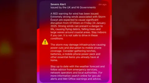
This evening between 17:00 and 18:00 GMT an alert was sent to people's mobile phones warning of "significant disruption".
"Strong winds present a danger to life, causing flying debris, falling trees and large waves around coastal areas," the alert said.
"Stay indoors if you can, it is not safe to drive in these conditions" it added.
Schools advised to close
In advice to schools the Met Office had warned of "very dangerous conditions" and "widespread disruption".
Education Minister Paul Givan said he understood the closure would affect the work of schools and other businesses but the decision had been taken "to avoid any potential risk to life for children and young people as well as staff".
"Schools should put plans in place today for remote learning so that pupils can study at home," he added.
The last time all schools in Northern Ireland were advised to close due to weather was due to Hurricane Ophelia in 2017.
Queen's University Belfast and Ulster University have said they will close on Friday as well as further education colleges.
What is the advice?
 Pacemaker
Police have warned people to expect serious disruption across the road network, public transport, schools, health services and other public services.
First Minister Michelle O'Neill advised people to work from home and avoid unnecessary travel.
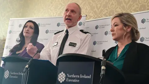
At a press conference at Stormont, O'Neill said she wanted to emphasise that a red warning was very serious and was only used when there was a genuine threat to life.
Deputy First Minister Emma Little-Pengelly added that people should stay inside where possible.
"We want to assure the public that we are taking it seriously and that must mean urging members of the public to take the advice that is given," she said.
"Hope for the best but to prepare for the worst."
 Getty Images
Ass Ch Cons Davy Beck said the Police Service of Northern Ireland had declared a major incident.
He said all non-essential operational activity and training had been cancelled on Friday so officers could focus on dealing with the storm and its aftermath.
In a post on social media, O'Neill added the executive was "working with emergency services and agencies to ensure a coordinated response to protect people and communities."
Bryan Monson, from the Health and Safety Executive for Northern Ireland, told BBC News NI's Talkback programme that "where its not absolutely essential, travel should be curtailed, people should stay at home and work from home where that's possible".
A number of supermarkets are set to be closed both in Northern Ireland and the Republic.

All Lidl stores on the island will close for the duration of the red warnings.
The company said they would reopen one hour after weather warnings were lifted in each area, as long as it was safe to do so.
Tesco has confirmed that stores in Northern Ireland will be closed on Friday until it is safe for them to open.
Meanwhile, Sainsbury's have said all stores in Northern Ireland will be closed from 07:00 GMT until 15:00 GMT on Friday.
An amber warning will also be in place in Northern Ireland from 06:00 until 21:00.
What does a red warning mean?
The Met Office says a red weather warning means dangerous conditions with widespread disruption.
It advises people to expect:
- Flying debris resulting in danger to life
- Large waves and beach material being thrown onto coastal roads, sea fronts and homes
- Very dangerous driving conditions with fallen trees on roads
- Power cuts affecting other services, such as mobile phone coverage
- Damage to buildings and homes, with roofs blown off and power lines brought down
- Roads, bridges and railway lines closed, with delays and cancellations to bus, train, ferry services and flights
It is the first time a red weather warning has been issued for Northern Ireland since an impact-based system was introduced in 2011.
Previous red warnings were issued on a different basis.
Travel disruption
Translink has announced there will be no bus or train services operating on Friday morning, while the red status is in place.
Translink's Director of Services, Ian Campbell said bus services would be reinstated "wherever it is safe to do so".
"It will be after 14:00 GMT. We do anticipate, however, there will be additional disruption once the storm passes," he added.
A number of flights between Belfast City Airport and airports across Great Britain on Friday have been cancelled, while Belfast International Airport has also warned people to expect delays and cancellations.
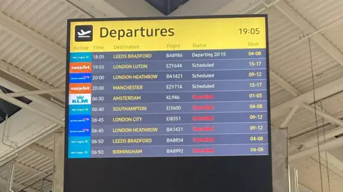
All Loganair flights from City of Derry airport on Friday are cancelled. The airport said further disruption is expected to "other flight schedules."
P&O has announced ferry cancellations between Larne and Cairnryan from 04:00 to noon and Stena Line services between Ireland and Great Britain are also severely disrupted.
Dublin Airport said there could be "some disruption" to Friday's flight schedule and that passengers should contact their airline directly for updates.
Hospital appointments
Four of Northern Ireland's health trusts are advising that all appointments are cancelled, or should be considered cancelled, unless you have been contacted specifically to say otherwise.
The South Eastern, Belfast, Western and Northern health trusts all say that this includes red flag cancer referrals and all scheduled appointments, with "significant disruption" expected.
The exception is emergency departments and care, which will be operating as normal.
The Southern Health Trust says all outpatient appointments and all elective surgery, including red flag and urgent, are cancelled.
Allow X content?
The Met Office suggest preparing for the storm in a number of ways, including:
- Protecting your property by securing loose items outside your home
- Gathering torches and batteries, a mobile phone power pack and essential items in case of a power cut
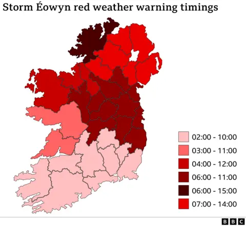
Storm Éowyn is the fifth named storm of the winter season, and follows Storm Darragh which hit on 5 December.
Winds are expected to rapidly increase on Friday morning with peak gusts of 80-90 mph (130-145 km/h) and possibly up to 100mph along some exposed coasts.
The strongest gust ever recorded in Northern Ireland was 124mph in Kilkeel in County Down on 12 January 1974.
A red wind warning was issued for the whole of the Republic of Ireland on Wednesday, with Met Éireann warning of a possible "danger to life".
There are other warnings across parts of the United Kingdom.
Republic of Ireland weather warnings
In the Republic of Ireland, Met Éireann has warned that "severe, damaging and destructive winds" are expected.
The red alert there comes into effect at various times from 02:00.
Speaking to RTÉ, chairman of the National Emergency Co-ordination Group said Storm Éowyn would "probably be among the severest storms" Ireland had ever seen.
An Garda Síochána (Irish police) warned all members of the public that a red severe weather warning means "shelter in place".
Meanwhile, a yellow warning for strong wind has been issued for Northern Ireland on from 08:00 - 15:00 on Sunday.
The Met Office is expecting a further period of strong of strong winds with gusts up to 60mph (100km/h) quite widely, and up to 70mph (115km/h) around exposed coasts and hills.
